
STUDIUM WROCŁAWIA
Spatial Development Study
The document has been approved by the City Council on January 11, 2018.
Urban Complex Page is one of many new concepts introduced in the document. It's a tool designed to improve readability of the Study.
study drawings
Download individual study drawings:
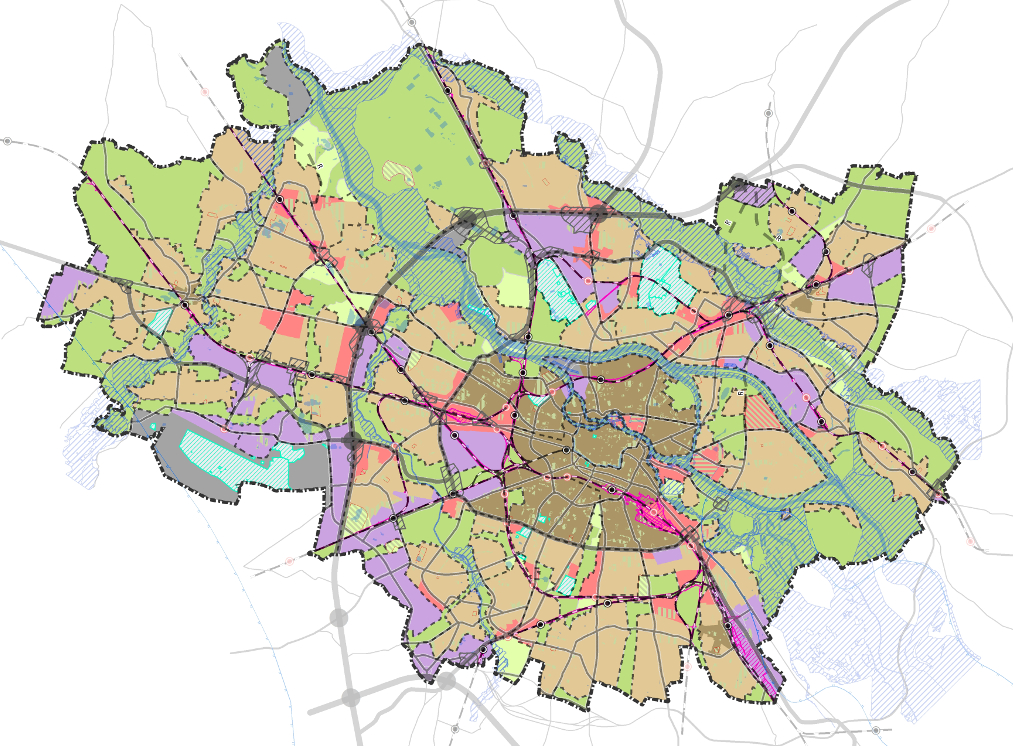
- Rys. 1. Uwarunkowania - przeznaczenie i zagospodarowanie terenów
- Rys. 2. Uwarunkowania - zieleń i środowisko
- Rys. 3. Uwarunkowania - dziedzictwo kulturowe
- Rys. 4. Uwarunkowania i kierunki zagospodarowania przestrzennego - polityka kompozycji
- Rys. 5. Kierunki zagospodarowania przestrzennego - struktura funkcjonalno-przestrzenna
- Rys. 6. Kierunki zagospodarowania przestrzennego - przeznaczenie terenów
- Rys. 7A. Kierunki zagospodarowania przestrzennego - parametry i wskaźniki urbanistyczne
- Rys. 7B. Kierunki zagospodarowania przestrzennego - parametry i wskaźniki urbanistyczne
- Rys. 7C. Kierunki zagospodarowania przestrzennego - parametry i wskaźniki urbanistyczne
- Rys. 8. Kierunki zagospodarowania przestrzennego - polityka zamieszkiwania
- Rys. 9. Kierunki zagospodarowania przestrzennego - polityka zieleni i środowiska
- Rys. 10. Kierunki zagospodarowania przestrzennego - polityka rzeczna
- Rys. 11. Kierunki zagospodarowania przestrzennego - polityka przestrzeni publicznych
- Rys. 12. Kierunki zagospodarowania przestrzennego - polityka dziedzictwa kulturowego
- Rys. 13. Kierunki zagospodarowania przestrzennego - polityka gospodarczo-usługowa
- Rys. 14. Kierunki zagospodarowania przestrzennego - polityka zrównoważonej mobilności
- Rys. 15. Kierunki zagospodarowania przestrzennego - polityka infrastrukturalna - energetyka
- Rys. 16. Kierunki zagospodarowania przestrzennego - polityka infrastrukturalna - sieci komunalne
- Rys. 17. Kierunki zagospodarowania przestrzennego - obszary wymagające rehabilitacji
- Rys. 18. Kierunki zagospodarowania przestrzennego - zagadnienia realizacyjne
previous Studies
Previous 2010 Wrocław Spatial Development Study
Figure 1. Conditions - current land use
Figure 1 download (pdf - 16 MB)
Figure 1 download (jpg - 18MB)
+ georeferencing file
Figure 2. Conditions and policy – spatial composition
Figure 2 download (pdf - 18 MB)
Figure 2 download (jpg - 20 MB) + georeferencing file
Figure 3. Conditions – cultural heritage
Figure 3 download (pdf - 19 MB)
Figure 3 download (jpg - 21 MB) + georeferencing file
Figure 4. Conditions – natural environment
Figure 4 download (pdf - 21 MB)
Figure 4 download (jpg - 24 MB) + georeferencing file
Figure 5. Policy – linear structure of the city
Figure 5 download (pdf - 2 MB)
Figure 5 download (jpg - 2 MB) + georeferencing file
Figure 6. Policy – spatial and functional structure
- Figure 6 sheet A1 download (pdf - 11 MB)
- Figure 6 sheet A2 download (pdf - 14 MB)
- Figure 6 sheet B1 download (pdf - 20 MB)
- Figure 6 sheet B2 download (pdf - 26 MB)
- Figure 6 sheet B3 download (pdf - 15 MB)
- Figure 6 sheet C1 download (pdf - 14 MB)
- Figure 6 sheet C2 download (pdf - 1 MB)
- Figure 6 sheet C3 download (pdf - 17 MB)
- Figure 6 download (jpg - 28 MB) + georeferencing file
- Figure 6 sheet A1 download (jpg - 9 MB) + georeferencing file
- Figure 6 sheet A2 download (jpg - 12 MB) + georeferencing file
- Figure 6 sheet A3 (legend) download (jpg - 4 MB) + georeferencing file
- Figure 6 sheet B1 download (jpg - 19 MB) + georeferencing file
- Figure 6 sheet B2 download (jpg - 25 MB) + georeferencing file
- Figure 6 sheet B3 download (jpg - 14 MB) + georeferencing file
- Figure 6 sheet C1 download (jpg - 12 MB) + georeferencing file
- Figure 6 sheet C2 download (jpg - 18 MB) + georeferencing file
- Figure 6 sheet C3 download (jpg - 16 MB) + georeferencing file
Figure 7. Policy – transportation system
Figure 7 download (pdf - 19 MB)
Figure 7 download (jpg - 17 MB) + georeferencing file
Figure 8. Policy – public transportation
Figure 8 download (pdf - 17 MB)
Figure 8 download (jpg - 16 MB) + georeferencing file
Figure 9. Policy – bicycle infrastructure
Figure 9 download (pdf - 17 MB)
Figure 9 download (jpg - 16 MB) + georeferencing file
Figure 10. Policy – nature preservation
Figure 10 download (pdf - 24 MB)
Figure 10 download (jpg - 22 MB) + georeferencing file
Figure 11. Policy – cultural heritage preservation
Figure 11 download (pdf - 19 MB)
Figure 11 download (jpg - 18 MB) + georeferencing file
Figure 12. Policy – planning and investments
Figure 12 download (pdf - 28 MB)
Figure 12 download (jpg - 26 MB) + georeferencing file
Figure 13. Policy – areas in need of rehabilitation
Figure 13 download (pdf - 18 MB)
Figure 13 download (jpg - 17 MB) + georeferencing file
Figure 14. Policy – infrastructure - sewage system
Figure 14 download (pdf - 18 MB)
Figure 14 download (jpg - 20 MB) + georeferencing file
Figure 15. Policy – infrastructure - water system
Figure 15 download (pdf - 18 MB)
Figure 15 download (jpg - 20 MB) + georeferencing file
Figure 16. Policy – infrastructure - heating
Figure 16 download (pdf - 18 MB)
Figure 16 download (jpg - 20 MB) + georeferencing file
Figure 17. Policy – infrastructure - electricity
Figure 17 download (pdf - 18 MB)
Figure 17 download (jpg - 20 MB) + georeferencing file
Figure 18. Policy – infrastructure - natural gas
Figure 18 download (pdf - 17 MB)
Figure 18 download (jpg - 20 MB) + georeferencing file
Read contents of the Study (Wrocław City Counsil resolution no. L/1467/10)
Obsolete 2006 Wrocław Spatial Development Study
List of figures is simmilar to 2010 Spatial Development Study, but they differ in their contents.
PDF figures:- Figure 1. Conditions - current land use (pdf - 5 MB)
- Figure 2. Conditions – spatial composition (pdf - 7 MB)
- Figure 3. Conditions – cultural heritage (pdf - 7 MB)
- Figure 4. Conditions – natural environment (pdf - 7 MB)
- Figure 5. Policy – linear structure of the city (pdf - 1 MB)
- Figure 6. Całość Policy – spatial and functional structure (pdf - 8 MB)
- Figure 6. sheet A1 (pdf - 4 MB)
- Figure 6. sheet A2 (pdf - 5 MB)
- Figure 6. sheet B1 (pdf - 7 MB)
- Figure 6. sheet B2 (pdf - 10 MB)
- Figure 6. sheet B3 (pdf - 6 MB)
- Figure 6. sheet C1 (pdf - 6 MB)
- Figure 6. sheet C2 (pdf - 8 MB)
- Figure 6. sheet C3 (pdf - 8 MB)
- Figure 7. Policy – transportation system (pdf - 6 MB)
- Figure 8. Policy – public transportation (pdf - 6 MB)
- Figure 9. Policy – bicycle infrastructure (pdf - 6 MB)
- Figure 10. Policy – nature preservation (pdf - 8 MB)
- Figure 11. Policy – cultural heritage preservation (pdf - 7 MB)
- Figure 12. Policy – planning and investments (pdf - 8 MB)
- Figure 13. Policy – areas in need of rehabilitation (pdf - 6 MB)
- Figure 14. Policy – infrastructure - sewage system (pdf - 7 MB)
- Figure 15. Policy – infrastructure - water system (pdf - 6 MB)
- Figure 16. Policy – infrastructure - heating (pdf - 4 MB)
- Figure 17. Policy – infrastructure - electricity (pdf - 6 MB)
- Figure 18. Policy – infrastructure - natural gas (pdf - 6 MB)
- Figure 1. Conditions - current land use (jpg - 18 MB)
- Figure 2. Conditions – spatial composition (jpg - 20 MB)
- Figure 3. Conditions – cultural heritage (jpg - 21 MB)
- Figure 4. Conditions – natural environment (jpg - 22 MB)
- Figure 5. Policy – linear structure of the city (jpg - 2 MB)
- Figure 6. Całość Policy – spatial and functional structure (jpg - 25 MB)
- Figure 6. sheet A1 (jpg - 10 MB)
- Figure 6. sheet A2 (jpg - 10 MB)
- Figure 6. sheet B1 (jpg - 18 MB)
- Figure 6. sheet B2 (jpg - 27 MB)
- Figure 6. sheet B3 (jpg - 15 MB)
- Figure 6. sheet C1 (jpg - 14 MB)
- Figure 6. sheet C2 (jpg - 20 MB)
- Figure 6. sheet C3 (jpg - 19 MB)
- Figure 7. Policy – transportation system (jpg - 20 MB)
- Figure 8. Policy – public transportation (jpg - 19 MB)
- Figure 9. Policy – bicycle infrastructure (jpg - 19 MB)
- Figure 10. Policy – nature preservation (jpg - 26 MB)
- Figure 11. Policy – cultural heritage preservation (jpg - 21 MB)
- Figure 12. Policy – planning and investments (jpg - 27 MB)
- Figure 13. Policy – areas in need of rehabilitation (jpg - 27 MB)
- Figure 14. Policy – infrastructure - sewage system (jpg - 16 MB)
- Figure 15. Policy – infrastructure - water system (jpg - 19 MB)
- Figure 16. Policy – infrastructure - heating (jpg - 18 MB)
- Figure 17. Policy – infrastructure - electricity (jpg - 20 MB)
- Figure 18. Policy – infrastructure - natural gas< (jpg - 19 MB)
Read contents of obsolete 2006 spatial development study (Wrocław City Counsil resolution no. LIV/3249/06)
Obsolete 2001 Wrocław Spatial Development Study
- Figure1.1-1 Linear structure of the city (jpg – 0,43 MB)
- Figure1.1-2 Commercial activity corridors (jpg – 0,41 MB)
- Figure1.1-4 Polycentric structure of the city (jpg – 0,39 MB)
- Figure1.1-7 Spatial and functional structure (jpg – 2,56 MB)
- Figure1.4-1 Transportation system (jpg – 2,12 MB)
- Figure1.4.3-7 Public transportation (jpg – 1,52 MB)
- Figure1.4.6-1 Bicycle infrastructure (jpg – 3,57 MB)
- Figure1.5-1 Infrastructure - electricity (jpg – 1,81 MB)
- Figure1.5-2 Infrastructure - heating (jpg – 1,68 MB)
- Figure1.5-3 Infrastructure - natural gas (jpg – 1,88 MB)
- Figure1.5-4 Infrastructure - water (jpg – 1,78 MB)
- Figure1.5-5 Infrastructure - sewage (jpg – 7,77 MB)
- Figure3.1.1-7 Nature preservation (jpg – 7,18 MB)
- Figure4.1-1 Planning and investments (jpg – 2,37 MB)
- Figure4.1-2 Local Plans (jpg – 1,84 MB)
Read contents of obsolete 2001 spatial development study (Wrocław City Counsil resolution no. XXXV/1126/01)
- Figure 1.1-1 Linear structure of the city (jpg - 2,2 MB)
- Figure 1.1-2 Commercial activity corridors (jpg - 2 MB)
- Figure 1.1-4 Polycentric structure of the city (jpg - 2,4 MB)
- Figure 1.1-7 Spatial and functional structure (zipped jpegs - 169 MB)
- Figure 1.1-7 Spatial and functional structure (jpg - 27,8 MB)
- Figure 1.2-13 Composition (jpg - 9 MB)
- Figure 1.2-13 Composition- city centre (jpg - 24,5 MB)
- Figure 1.4-1 Transportation system (jpg - 14,8 MB)
- Figure 1.4.3-7 Public transportation (jpg - 10,2 MB)
- Figure 1.4.6-1 Bicycle infrastructure (jpg - 7,1 MB)
- Figure 1.5-1 Infrastructure - electricity (jpg - 9,4 MB)
- Figure 1.5-2 Infrastructure - heating (jpg - 8,2 MB)
- Figure 1.5-3 Infrastructure - natural gas (jpg - 9,6 MB)
- Figure 1.5-4 Infrastructure - water (jpg - 9,2 MB)
- Figure 1.5-5 Infrastructure - sewage (jpg - 9,7 MB)
- Figure 3.1.1-7 Nature preservation (jpg - 23,7 MB)
- Figure 3.2-1 Cultural heritage preservation (jpg - 10,9 MB)
- Figure 4.1-1 Planning and investments (jpg - 19,3 MB)
- Figure 4.1-2 Local Plans (jpg - 20,7 MB)